
Are Water Levels Affecting River Cruises on the Danube? A March–May 2026 Outlook
The Danube River constitutes a critical transboundary artery for European ecological sustainability and the rapidly expanding luxury river cruise industry. Spanning approximately 2,850 kilometers from its headwaters in Germany to its delta at the Black Sea, the river basin intersects nineteen distinct nations and requires highly specific hydrological conditions to accommodate the rigid physical parameters of modern 135-meter passenger vessels. In the immediate operational window of Spring 2026, the basin is undergoing severe, localized hydrological volatility driven by early snowmelt, concentrated Alpine precipitation, and structural climatological shifts.
High water in the west is currently disrupting itineraries. Prepare for sudden operational changes if you are sailing soon.
For worldwide cruise tourists actively monitoring their March and April 2026 Danube departures, understanding the localized realities of the river’s shifting state over the next 90 days is critical to setting accurate expectations.
March 2026: The Upper Danube Crisis and “Rain-on-Snow” Events
The immediate narrative for March 2026 is defined by a rapid, violent hydrological reversal in Germany and Austria. The winter months were characterized by heavy snowpack in the Bavarian Forest and sub-zero temperatures that required icebreakers near Regensburg. However, atmospheric pressure patterns shifted dynamically in early March, bringing a persistent influx of mild air into the Alpine forelands.
This thermal shift radically accelerated the melting of the accumulated snowpack. Compounding this anomaly, heavy and sustained rainfall events moved over key tributary basins, most notably the Isar and Regen river valleys. Because the frozen, highly saturated ground possessed a fundamentally diminished capacity for water absorption, massive volumes of surface runoff funneled directly into the main trunk of the Danube network.
This rapid swelling fundamentally eliminates the vertical clearance, or “air draft,” required for a vessel’s steering house and radar masts to pass safely beneath the 89 historic bridges spanning the Upper Danube.
If a ship cannot fit beneath a bridge, it stops. Period.
As of mid-March, real-time hydrometric data indicates active disruption in the German sector:
| Gauge Station | March Operational Status | Direct Navigational Impact |
| Pfelling (Germany) | Breached Flood Level I (580cm). | Rapidly approaching the 620cm mandatory commercial traffic suspension threshold. |
| Passau (Germany) | Severe High Water (611cm). | Hazardous clearance at the Luitpoldbrücke. Passage often impossible at 630cm. |
| Vienna (Austria) | Compound Delays. | Elevated water levels are clashing with scheduled lock maintenance at Aschach, reducing throughput. |
April 2026: The Flood Wave Propagates Downstream
As we project into April 2026, the intense volume of water currently bottlenecking the Upper Danube will be forced downstream. The river traverses the vast topographical depression known as the Pannonian Plain, flowing through Slovakia and Hungary. From a hydrological perspective, this expansive region acts as a massive natural buffer.
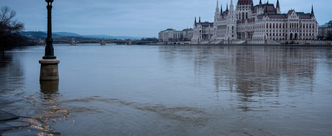
As the violent flood waves generated by the pluvial events in Bavaria propagate eastward, the broader floodplain topography and decreased gradient of the Middle Danube naturally attenuate the peak discharge. This effectively flattens the flood curve before it reaches major metropolitan and touristic centers like Bratislava and Budapest. Consequently, while early April sailings in Germany will still face the lingering effects of high water and saturated riverbanks, operations in the Middle Danube will stabilize.
Budapest will absorb the delayed volume safely. Cruising in this sector remains highly viable.
According to the Hungarian Hydrological Forecasting Service, the Budapest gauge is successfully managing the upstream influx. Tourists booked on localized Middle Danube focused itineraries during April will experience optimal, standard navigational conditions. Furthermore, local civic events, such as the Hungarian parliamentary elections scheduled for April 12, may mildly impact the routing of urban shore excursions but bear absolutely no bearing on riverine operations or vessel safety.
May 2026: The Lower Danube and the Threat of Early Drought
The narrative shifts entirely as we look toward May 2026 and examine the free-flowing Lower Danube, which demarcates the border between Bulgaria and Romania. Unlike the heavily engineered and impounded Upper Danube, the Lower Danube is characterized by vast, expanding widths, constantly shifting sandbanks, and a notoriously shallow gradient.
In this sector, the primary, existential threat to the river cruise industry is not high water, but historically low water. The region is currently draining its accumulated winter baseline volume at a rapid diurnal rate. Advanced mechanistic hydrological models, such as the Soil and Water Integrated Model (SWIM), map a structural shift in the Danube’s discharge seasonality. They predict an increasing frequency of significantly wetter early springs in the Upper Danube, juxtaposed against dramatically drier, hotter early summers in the Lower Danube.
If the spring freshet fails to replenish the lower basin, drought protocols will be activated by late May.
Should a premature early-summer heatwave drastically accelerate evaporation in May, the region will rapidly face drought-like conditions. The primary mechanical disruption to cruise operations on the Lower Danube involves the shifting hydro-morphology of the riverbed itself. Relentless siltation creates shallow “bottlenecks” that require continuous monitoring and capital-intensive maintenance dredging. When water levels drop below the Lowest Daily Clearance (LDC), navigation becomes dangerous or completely impossible for deep-draft vessels.
Currently, depths at critical shifting shoals like Vardim Island and Belene Island read above 5.3 meters, well above the 2.5-meter minimum requirement. However, late May travelers must monitor these gauges closely.
How the Cruise Industry Mitigates Seasonal Disruption
The extreme volatility of the Danube’s hydrology is not a novel phenomenon. The river cruise industry has evolved sophisticated, highly capitalized operational mechanisms to absorb and mitigate these environmental shocks. Operators rely on highly codified contingency protocols driven by advanced 6-to-7 day predictive forecasting from the EU-funded FAIRway Danube II initiative.
Expect itinerary modifications. Flexibility is not optional during the spring shoulder season.
If your booking falls within a high-risk operational window, you will likely encounter one of the following logistical defenses:
- The “Ship Swap” Maneuver: Operators with standardized fleets will sail two identical ships toward a blocked bridge or low-water chokepoint from opposite directions. Passengers, alongside their luggage, are disembarked, bussed around the obstruction, and boarded onto the sister ship to continue the itinerary in reverse.
- Shallow Draft Architecture: Companies like AmaWaterways engineer vessels with exceptionally shallow drafts, granting them enhanced operational viability during the low-water events projected for the Lower Danube in May.
- Bus-Bridging and Hotels: If a ship swap is geographically impossible, operators will unilaterally alter the itinerary to utilize extensive overland motorcoach networks and local hotel stays.
While these logistical maneuvers ensure you will still see the historic sites promised on classic European river voyages, they temporarily transition the experience from a seamless river transit to a terrestrial bus tour.